Saturday, 30 April 2011

Naked walls in the living room.

Things have been going very slow on the house. Much slower than planned, mainly because we are still waiting on the planning application, which we expected to be through at the end of March. It's basically through, just waiting on some formalities and paperwork, so we're in the process of finalising working plans to get quotes.

In the meantime, I've been doing more clearance work in the living room, slaughter room (I really should start calling it the kitchen now) and one of the bedrooms on the first floor.

In the last post, I showed the first steps in the living room, removing the partition wall and revealing the oak beam which was cracked. Since then, an engineer paid us a visit (well, we'll be paying him) and said it could either be replaced with a steel beam, or can be left in situ, though a post would have to remain to support it. I'm assuming replacing it with a steel beam with be costly, although we won't know for sure how it might be done until I take down the ceiling.

Dry lining removal continued over last week (I had an enforced break from heavy work after falling and bruising my spine a few weeks ago, which also delayed our own works), so the walls in the living room are now plasterboard-free. You can do a before and after using the first living room post.

Living room, April 2011.
In the room to the rear, I was surprised to find bare stone walls behind the plasterboard. In all other areas there was still old plaster with layer upon layer of old paint, often with wonderful stencilled patterns still remaining. There are still traces of clay-based plaster between the stones, so presumably plaster was removed before sticking the Styrofoam-insulated plasterboard onto the walls. More on that below.

I like the idea of leaving one of these walls exposed, cleaning it up and re-pointing the stones. The back wall will be insulated from the outside, but unfortunately the west wall (left in the photo to the right) will be insulated from the inside.

The opposite wall was clearly scoured before the plasterboard was "glued" to the wall with blobs of plaster. Several layers of paint and thin plaster have been exposed, with some of the earliest showing as turquoise, with brown, geometric flowers stencilled on. The brighter patch on the right, as seen in the photo to the left, is not wallpaper, it's actually a white or cream base with a stencilled pattern. At the top left, the underlying bricks are exposed, which don't exactly look ancient. This part of the wall is thinner in plan (see the floor plan at the top of this post), and it is possible that there was formerly a door here that was later bricked up.

Section of the fuchsia pattern.
In the southern part of the overall living room (the large room before the partition was taken down), there was no plasterboard, so once the wallpaper was removed, the old paints were exposed. There are six or more layers, probably, thogh only the most recent can be seen to any great extent, the rest are only exposed in small, enticing sections. As it happens, I think the latest one was very pretty and delicate, being a stencil of what looks like fuchsia in five colours. This was rendered in repeating patterns, spaced about 80cm apart, with geometric patterns of circles of radiating lozenges and wavy lines between.
The fuchsia stencil.
Next step in this room, take down the plasterboard ceilings to make sure there are no surprises hidden above.

Sunday, 3 April 2011

First steps with a crowbar.

The living room.
We're still waiting on the planning permission to come through, about two or three weeks longer than expected, but we know it's now just waiting on one document to be signed by the neighbours. It's time to get things moving, and get more detailed plans for specific works ready, and start getting quotes.


In the meantime, we've been getting the vegetable garden out back into shape, and over the weekend I began taking out the thin wall that has been dividing the two rooms on the west side of the 1st floor.

A reminder: the living room, January 2011, taken from the southeast corner.
Use of hammer and crowbar to reveal innards.
We knew this wall was "new", all things being relative. It was about 5cm thick, and on the north face of it, there was clearly a large post within the wall, supporting a beam running across the room. After taking wallpaper off, it was confirmed to be plasterboard, put up on the 8th of June, 1998 (the date was written on it!). On Saturday, I took the plasterboard down from the south-facing side I expected to see a partition frame and the back of the plasterboard on the other side, but was faced instead with paneling, that looked like it had been salvaged from elsewhere. The most exciting part of this was exposing the beam, which can be seen on the top-right of the photo to the right. It's seriously bowed, hence lots of spacers to level off the plasterboard it was covered by, but the painted decoration was nice to find, so looking forward to exposing the whole length.

Painted decoration on previously hidden beam.
Wall mostly gone, bow in beam clearly visible.
 Once the paneling and other side of the wall were down, it was clear that a more substantial wall had previously been here, There are mortice holes in the under-surface of the beam, but I can't explain why more substantial oak beams were removed and replaced by a relatively flimsy partition. Or can I?
We assumed the post that we knew was in the middle of the span was there as part of the wall, as the span is relatively short, and there are longer spans unsupported, even in the same room. However, it became clear that it was supporting the beam, which is heavily bowed (and not unusual for such buildings). However, it also became clear that the beam has a rather large crack, so this support is essential.
 
First clue about cracked beam.
This beam is anchored to the gable end of the house, and the other end into a supporting internal wall. It seems that the lower part of the gable wall settled some time in the past (one assumption is when modern drainage was run alongside the house, possibly causing the foundations to shift a bit), forcing the gable to tilt. This caused a gap that can be seen in the ceiling in the cellar, but clearly also put this beam under considerably more tension that it could deal with, so it snapped. It's worrying, insofar as a part of the house has moved, but it would seem that this movement was in the last 40 years (and none apparent after June 8, 1998!). At least the architect (for whom I have great respect) said not to worry!
Crack confirmed on the other side.
As it happens, we will meet with a structural engineer this coming week to talk about what walls can be broken through. This beam, and the crack in west gable are now going high on the list of things to talk about.

I like the crowbar. I even had my Gordon Freeman work glasses on while wielding it!

Sunday, 20 March 2011

Inside the Barn

The grand entrance.
The last barn post had a little about how the barn developed over the years. What I hadn't noticed, till recently, is the year 1905 above the main door. I doubt very much that the piece of plaster the date is on comes from 1905, but it may be a clue as to when the original, simple structure was built, 65 years after the house. Doesn't seem right, but as the house itself housed animals, it could well be.

It's difficult to describe the inside of the barn without referencing how it developed, so I won't bother going into detail here. Just read back to the previous post if a year is mentioned here. Instead, we'll take a brief photo tour, with descriptions.

The main door is 3 metres high, so plenty of room for getting a tractor and trailer in. The lower 3m is stone, with the rest being half-timbered, with 14x14cm oak beams, brick and clay-based plaster. Luckily there's a small, person-size door built into the main door, so it doesn't have to be opened every time.

Upon entering, on the left, there is a small cellar that is not indicated on any of the plans, so we don't know when it was constructed. This area has a low ceiling, with large beams supporting a hay/straw storage area above.

First small cellar on north side (left as entering).

Door to second cellar.
Further to the back is into the area that was extended in 1922, and again in 1947. The door in the photo to the right leads to the cellar in the northeast corner. The wall immediately to the left of the doorway is the eastern wall of the original small barn, so it was quite a modification, removing several metres of the original back wall to extend the main hall. There's a storage area immediately above the cellar, in a fairly awkward arrangement, presumably as there was originally a low, lean-to roof over it until the later extension. This means the floor here is not on a level with the other "floors", as represented by the beams running across the top right of the photo.

Inside the cellar.
Upper levels, looking north.
The two phases of construction can be clearly seen inside this cellar, with slightly different finishes and aging on the left and right sections of the wall opposite the door (the left side of the photo above). The window in this wall was originally a chute, as was the one on the right after 1947, however this has since been covered with earth on the outside (it can be seen that water seeps in if it's wet outside). This will be cleared away and the chutes will be turned into windows to let a little more light in.

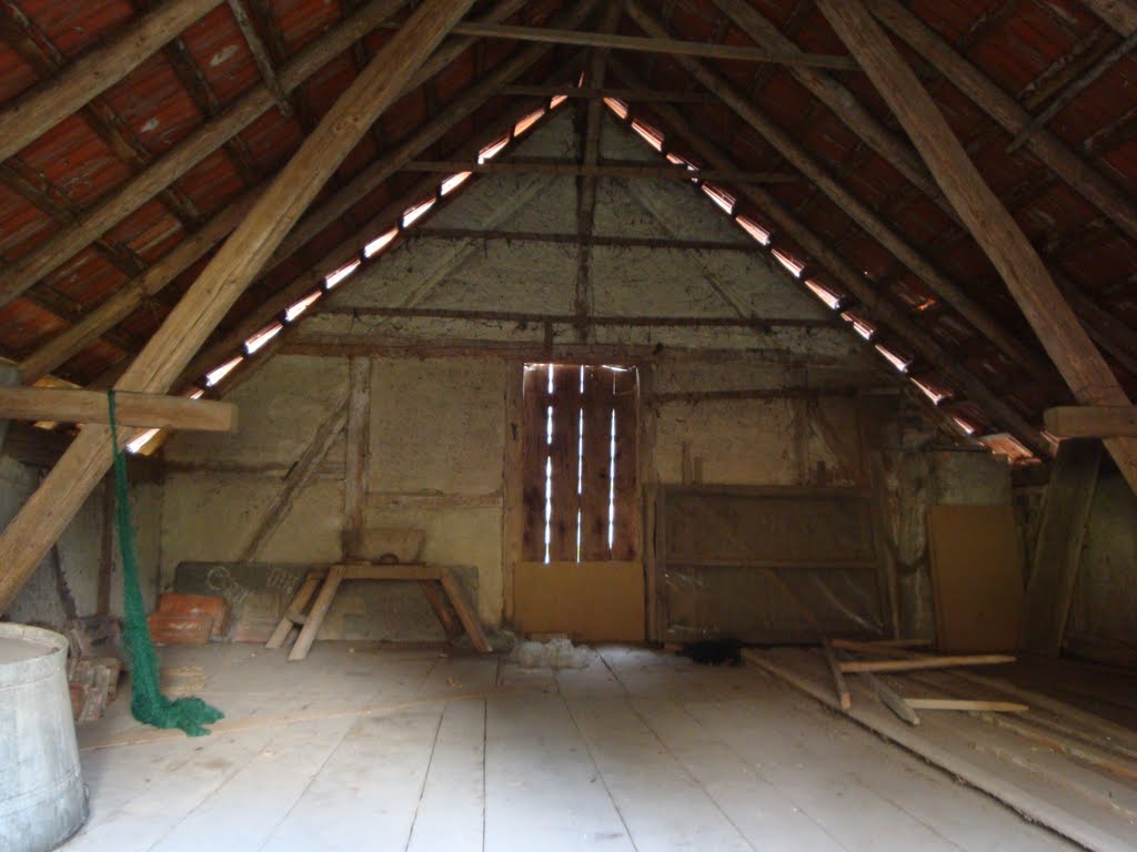
Staying on the left side as you enter, above these cellars is large, open space. I'm still estimating, but it must be more than 13 metres from the ground to the apex. The space is crossed with hefty 26x26cm oak beams. I'm pretty sure another floored level or two could be easily accommodated.
Upper levels, looking east from above the first level.

Southern gable of main barn
To the right of the main hall is more or less open space. Once interesting feature is that the gable from the previously adjoining neighbours barn is still there. We know this was from the neighbours barn as the iron anchors that used to tie the gable to the oak cross-beams are still there, hanging useless. The black bar, just below and to the right of centre, would have been in the external wall, from the perspective of the neighbour.

The beams running across the empty space would have held up hay, keeping it aired, and there are boards lying around to be used as temporary flooring.

In the centre of the main hall is what could be considered a shaft, across which no timbers cross. A winch used to operate a hoist here, to lift materials to the higher levels. We'll come back to the winch room in another post.

The extension to the south, which was built in 1960, is a much simpler affair, being a lean-to in form, and consisting of an open plan feeding hall, with hatches along the southern wall allowing feed to be popped directly into the troughs on the other side. Entry to the hall is via a pair of large, sliding doors. To the left, there are two openings leading into the main barn.
The feeding hall.
The other side was then, of course, all stalls, in a kind of building within a building, as can be seen on the right of the photo above. There are lots of south-facing windows in the stalls area, so it's nice and bright. The posts are not supporting, so we'll probably remove them to open this up a bit and use it as a workshop.

The stalls.

Monday, 28 February 2011

The Barn

Location of the barn.
The barn is a massive structure, with a 360 sq.m. footprint (c. 23x16m), and around 12m high at the highest point, giving it a rather large volume. As described earlier, it has undergone considerable extension, starting with a relatively small rectangular footprint, with stone construction for the lower 3m, and the remaining as half-timbered, much as it is today.

This modest barn was extending into an irregular polygon (see the red elements in the plans below) around 1922 when the main hall was extended, incorporating a ground floor cellar. The odd-shaped footprint seemed to be on account of the plot of land being irregular, and the little corner that would have made it square falling on a neighbour's plot of land.
 
Extension floor plan, August 1922.
Extension elevation and sections, August 1922.


By 1947, this was resolved, and the building was squared with another extension, enlarging the cellar at the same time. The plans we have from this time illustrate what it must have looked like back then rather well (see the elevations at the bottom of the image below), and show a much more complex roof surface than exists today.
Extension proposal, May 1947.
 At this point in time, the southern side of the barn (or the left side, when looking at the Hintere Ansicht (Ost), at the lower left of the image above) was adjoined by a neighbours barn, unfortunately not shown in these plans. By 1960, this adjoining barn was razed, and a "modern" extension built onto the southern side housing stalls and a "feeding hall".

Extension proposal, April 1960

At some point in time, the roof on the main barn was simplified into the two surfaces it currently has, but we have no records of when that was done, but presumably between 1947 and 1960.

The barn viewed from the east, January 2011.

Lots of ladders in the main hall.
The main building currently comprises of a central hall, to the north of which are two “cellars” (one was not marked on the above old plans), which are partially underground owing to the barn being built into a slope. Above this is a large, open volume, currently home to bails of straw, spread across several “floors”, for want of a better word. Some of these floors are made of planks, some are simply round timbers laid between the large beams, allowing air to circulate  below the straw, which essentially provides a surface to walk on. One level is like a room within the barn, with a door at one side, but open on the other, the reason for which is a complete mystery to me, but may represent an upper-level door in the former external wall of the original barn. Several ladders, firmly attached to the structural beams, provide access to these upper levels, and are not a climb for those suffering from even the slightest touch of vertigo.

The stalls in the 1960s extension
The extension on the southern side is simple, being divided into two halves, one with a large door for access, and the other with a smaller door. The former might be described as a feed hall, with hatches providing access to the feeding troughs in the stalls housed in the southern half.


Former line of gable at southern end clearly visible, January 2011.

We have no concrete plans for the barn at this stage. The structure appears sound, though some spot repairs to edges of the roof and the gutters is required. We’d like to replace the asbestos sheeting roof of the extension with something else, but even that will have to wait a couple of years, as it is not currently a risk, as they are not decaying. The cellars could do with some freshening up, and the exposed steel beams of their ceilings treated with a rust preventer, and we’ll dispose of the straw, most likely giving it to someone in the locality whose barn burnt down, and who needs bedding for his horses. The stalls would make a great workshop, as it's bright and airy there, so that might be where some of the old furniture will get restored.

However, the biggest short-term job that needs to be done is satisfying the requirements of fire protection, and new rules that came in a couple of years ago. As the house is almost touching the barn, certain measures (we're not sure what yet) have to be taken, but at least the timbers are over a certain dimension threshold, and it appears the filling between the timbers is brick and plaster, and not wattle and daub, which helps. Fire retardant materials or windows may need to be used on the eastern gable of the house to satisfy the rules, which we believe are the remaining outstanding issue for our planning application.
The barns from the front, January 2011.
Of course the brewer in me has all sorts of dreams for the barn, but that’s another story.

I'll post more photos of the interior once the weather brightens up.

Saturday, 26 February 2011

The Schweinestall

Location of Schweinestall.

Let's begin a tour of the outbuildings. On the map to the right, is a small building (highlighted green), approximately 6m x 6m, marked as "Schu", just to the north of the house. This is the former Schweinestall, or pig sty, with a tobacco drying house, built around 1924, and which has lain unused for quite some years.

From the ground plan in 1922, it looks like there was an earlier building, not so deep (perhaps measuring 6 x 3 metres), already here, so perhaps this was a major extension and the blue shading on the cross section in the building plans from 1924 (below) indicates some earlier, reused structure.

Building plans from January, 1924.
The south facade (see photo below) isn't constructed exactly as planned, but I think it's prettier. In fact, even though it's more recent than the house (by at least 80 years), and the materials used were cheap and not the best quality, it has a nice rustic charm.

The chimney indicated on the plans no longer goes out the roof, but it is still present inside.


South facade of Schweinestall, February, 2011.

Lower level.
The lower door leads to the former pig sty, which was more recently used for chickens. There's not much natural light at this level. The windows at the south are small, and there's only one low window on the north, just above ground level, as it's built into the slope behind the house. On the left are concrete walls behind which can be subdivided into a number of stalls. The right is a wood and chickenwire construction. Each side of the walkway has two wooden posts supporting the large beams above.

The door at the top leads into a former tobacco drying house. Instead of getting a ladder every time we want to get into it, it's easier to walk around the back where you can duck into an opening in the wall (see photo below). The neighbourhood kids like to play in here, apparently, but so does the Marder.

Schweinestall viewed from the north.
The top level is open and roomy, and as befits a drying house, there's plenty of air moving through. We've applied to change the use of this building, with the idea of turning it into a work room/home office. The architect suggested putting a toilet and running water into the lower level which is a good idea, giving further options for the future. The top level door, seen below from the inside, would be turned into a window, as would the rear entrance, with access to the top level being provided by a small staircase within. This is probably still not enough for light, so a roof window is proposed on the eastern roof surface. Whether we do this conversion in the next year is dependent on how the main house work goes, and if not, a home office can go into the top attic level of the house instead.

Top level, February, 2011.
From the side, it can be seen how the current extension to the house makes for a bit of a tight fit, so once this is removed it will open up the back. The photo below also shows the degree of slope of the garden immediately behind the house, with a small retaining wall immediately behind the extension. Ultimately, we'd like to level this area with a retaining wall further back, to form a terrace with easy access to the kitchen.


Schweinestall viewed from the east, February, 2011.


Sunday, 20 February 2011

Images from the Past.

Having had a look at how the property and surrounding buildings developed from 1922 to the present, as seen from above, here's a quick look at what the buildings looked like in the past, thanks to some photos from the family that built and lived in the house till recently.

The Bauernhaus, date unknown.

The first photo is from an unknown date. We were told it could be the 50's, based on who the man is thought to be, but the style of dress make us think perhaps the 1930s. If anyone looking at this is an expert on historic German farmer clothing styles, let me know!

The thing I like about this image, apart from the pose and the young boy with a cheeky grin sitting behind the man, is it really shows that this was a working farmhouse. Manure and straw has been cleaned out of the stalls on either side of the house. There was a pump right outside the front door, and indeed, from other photos of the village, pumps dotted the area. We know that the water table is high in these surrounds (the cellar is proof of that), and I wonder if a hand pump could be reinstated.

The window boxes are a nice feature, and we still have one, or at least one in the same style, hanging on one of the outbuildings that we'll look at in a later post. To the right of the window just above the main door is a tube for inserting flags. We know because it's still there.
The Bauernhaus, October 2010

What is sad, is the original door frame of red sandstone, interestingly painted white back then, is most likely gone, and not hidden behind the rather ugly tiles that surround the main door now. The current door is wider than its sister opening to the right, while in the old photo, they look about the same, so the chances of removing those tiles to expose a sandstone frame look slim.

I just realised, that the half-doors on the stalls in the top photo are very likely the same ones there today!

Yellow buildings visible in photo.
The other photo (and unfortunately it's a photo I took today of a photo, but I will try to get it again for a scan), doesn't show the house, but dominating the left of the frame is the gable end of a neighbouring house that no longer exists, but which is most probably the building that was still extant on the mid-left of the maps from 1960. That house was certainly knocked down soon after 1960 to build a town hall, which was also knocked down in 2009 or 2010 to make way for a much larger, and very modern-looking town hall, thankfully a little further away from our house.

What is certain is the identity of the buildings in the background, and the small building to the right, presenting the gable end. This is the small building that was knocked down in 1960, and behind it is the neighbours barn, which adjoined our barn until the same year, when it was bought and demolished to build lean-to stalls (see the yellow-shaded buildings in the map to the right). The left hand gable of that former barn is now part of the gable end of our barn, which has since increased slightly in height during the various extension phases.

Neighbouring buildings, date unknown.
The view now, February 2011.
Like most of the photos we've seen of the village, this illustrates the community spirit of villages at the time, as the men of the neighbourhood went off to cut trees (or so we were told). It also shows the former access to the house, which is now the car park (still under construction) for the new town hall.

Any experts care to suggest a year for that tractor?

Sunday, 13 February 2011

The Lay of the Land

Before taking a closer look at the outbuildings, I thought it'd be useful to set the scene with a look of how the complex has developed over the past 100 years (well, about 90) based on plans we were given by the previous owners.

Lageplan from February, 1922.
In 1922, the then owner had applied to extend the barn (the extension marked in red on the plan to the right shows the planned extension to the barn, 179), so we have a general plan of the lands immediately surrounding the house from the planning application. Those plots of land and buildings marked as 179 were part of the property (I've shaded out everything else to make it clearer). Bearing in mind that this was a working farm, it seems small, but we know there were other land holdings nearby, and indeed these were still part of the overall property till we bought the house and immediate surrounds. The corridor marked by the two parallel lines at the bottom of the plan is a small stream. The building, marked 180, was another barn owned by the neighbour. Access to the house and the barns was via a small way, just leading left of the neighbour's barn. It's also interesting to note the little extension at the back of the main house. The current extension is wider than this, but it shows that there was something there before. In fact, this was a bake house, something the previous owner had mentioned, but we hadn't realised how important a part of the house this was till we saw another plan from 1937 that shows the house still divided into two separate halves (note no doors between the halves, and still two sets of stairs, one of which is now gone), and a Backkueche in one.

Floor plan of 1st floor, March 1937.


Lageplan from March, 1937.
It's odd that the ground plan in 1937, shown below, doesn't include the barn extension that was planned in 1922, but we know from later plans that it was most certainly extended, but we'll take a look at the development of the barn in another post. Perhaps plans were not being updated during the war years. The 1937 plan we have was for other works on the main house (a new chimney, and we think new windows on the eastern gable), so the extent of the barn was not essential to the planning.


Lageplan from March, 1960.
By 1960, the property boundaries had simplified considerably, between exchanges of land and a general straightening of boundaries, presumably as the lands around this area were, and indeed still are, part of a Flurbereinigungsgebiet - a rural land consolidation area where slivers of land are exchanged to simplify borders. We have a ground plan because there was yet another application to extend the barn. This time, the adjoining barn of the neighbour (shaded in yellow), and the accompanying plot of land on which it sat, was bought, and the older barn demolished to build an extension for stalls to the barn, which by this time has already been considerably extended. We don't know what the smaller building to the west, also shaded yellow, was, but it was probably knocked down at the same time. Access to the house at this time was still via the small "Weg". By now, the stream may have been partially covered, as it is today. We don't know when the access road at the back of the property dates from, as it was not shown in any of the earlier plans, but it provides a decent access to the land behind the house.

Lageplan from December, 2010.
Not much has changed to the boundaries since then, but the current plan shows the extent of the barn as it is today, more or less three times the size of the original footprint. As a former surveyor, I also have to laugh that the extension to the house (Whs - Wohnhaus) has still not been updated since 1922, as the "new" extension that replaced the former oven is actually twice the width. The biggest change seems to be access, as the former Weg which approached the house at an angle is now a straight road running north-south (and we own part of the paved street).

In total, the plot of land is just short of 3,000 square metres, or about 3/4 of an acre (unless it's an Irish acre). It feels bigger, especially when contemplating cutting the grass.